Lake Mountain tunnel
- Regular traffic: cars and trucks, your own vehicle
- West portal off Eagle Mountain Boulevard near city center
- S-curve under the ridge
- East portal near Pelican Point / south Saratoga, by the lake
Charlie Kirk Memorial Crossing
Utah · Vision site · September 10, 2026
We’re proposing a public highway: a tunnel under Lake Mountain, then a stilts bridge across Utah Lake, so Eagle Mountain and Cedar Valley can get to Provo and the Front without always going the long way around.
This is a concept. It is not funded, permitted, or endorsed by UDOT, MAG, or any city.
Cedar Valley is filling up with homes, power users, and tech. Lake Mountain and Utah Lake still make you drive around. People in Eagle Mountain feel stuck on the wrong side of the ridge. Utah Valley keeps packing more onto I-15. That’s just the map talking.
Pony Express riders already crossed this country with the mail, short hard relays between stations, tying towns together when waiting weeks was the alternative. Pioneers did it with wagons. Charlie Kirk spent his life connecting people through talk and conviction. We want a memorial that does the same thing on the ground: opens a path, doesn’t just put up a plaque.
Charlie Kirk spent his life pulling people into conversation: campuses, debates, hard topics most folks dodge. He believed communities get stronger when people show up and talk to each other, not when they stay sealed off.
That fits this corridor. Cedar Valley and Utah Valley are neighbors with a mountain and a lake between them. Naming the crossing for Charlie is a way to say connection still matters here, the same way Pony Express riders once carried mail across this country so towns weren’t cut off from each other.
The site launches September 10, 2026, one year after his death. The road itself will take longer. The name is the commitment to keep building toward each other.
Two builds that only work as a pair.
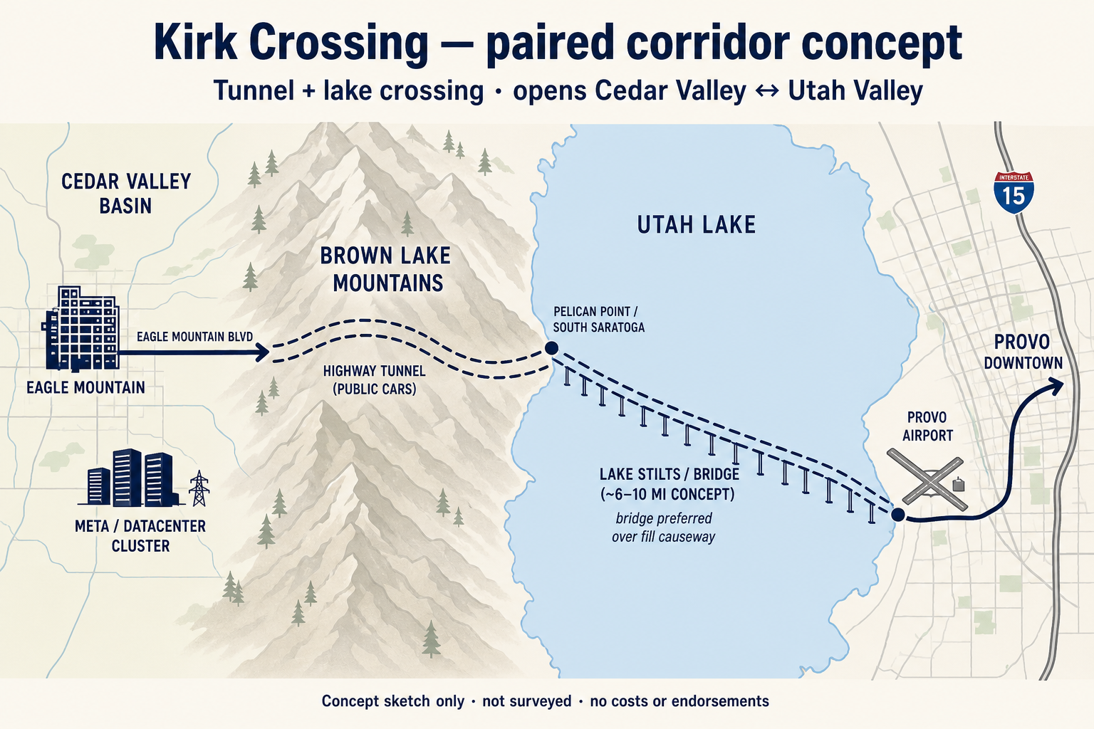
Jobs and schools on the Front get closer. The west side can grow without pretending the mountain isn’t there.
Not magic. Just another way east so everything doesn’t pile onto the same freeway.
Datacenters and power-heavy campuses need land. Workers still need a real path to Provo and the airport.
The political case first: growth is already on MAG’s map. This corridor is about whether Utah turns geography into capacity.
A tunnel-and-bridge program of this class would support years of temporary construction work for Utah trades and suppliers. Federal research talks about highway capital spending supporting job-years nationwide (CEA has cited roughly 13,000 job-years per $1 billion of investment, with big caveats). Construction peaks are temporary. Permanent tunnel and bridge ops jobs are much smaller. A project-specific headcount waits on a real cost study.
MAG’s TransPlan50 anticipates Utah County near 1.3 million people by 2050, with employment nearly doubling. The west side, from Lehi through Eagle Mountain and Saratoga Springs, carries a heavy share of that surge. Cedar Valley already hosts power-hungry industry and tech campuses that need Front labor, Provo Airport, and downtown within reach.
Major tunnels and bridges are built to serve many decades (Seattle’s SR-99 FEIS framed facility life at 75 years or more). Utah County’s plans already look past 2040, including a lake freeway or bridge that still needs location and engineering study. UDOT leaders have said any lake crossing is multi-billion territory. Whether this corridor produces net fiscal returns over generations is unknown until UDOT and MAG-grade analysis exists. What is known: the growth pressure and the mountain-and-lake bottleneck are already official.
Sell this to Utah first: MAG planning, UDOT process, cities, and the legislature. A verified benefit-cost ratio does not exist yet. Concept only. Not funded or permitted.
Straight talk. Utah leads. Washington helps later if the project is real enough.
This is multi-billion-dollar territory. The lake span is the expensive half. There is no official cost number yet.
Not twins. Just helpful scale checks so people know this isn’t a landscaping job.
Long stilts highway over a shallow lake. Shows you can drive miles on piles without sitting on bedrock. Ours would be shorter water, but meaner ground (soft fill plus Wasatch quake risk).
About two miles of public highway tunnel under a city, finished in the late 2010s. Tunnel program cost on the order of $2 billion. Useful as a “short highway tunnel is still huge” marker, not a Utah price quote.
Miles of bridge and underwater tubes carrying highway traffic across open water. Same idea as pairing water crossing with serious civil engineering, different coast and geology.
Right in our backyard: roughly $1.4 to $2.1 billion this decade for Mountain View, Cory Wride, Pioneer Crossing work, and the 2100 North link. Those are big Utah projects. Tunnel plus lake stilts would sit above any single piece of that package.
The live local plan is a surface arterial around or over the mountain, with published session figures around $120 to $140 million (2028 dollars) for one grade option. That’s the official-scale baseline. Our tunnel is a different ambition.
Modern example of a major highway bridge on deep soft ground where bedrock is absurdly far down. Friction piles and heavy engineering, not a Utah twin, but proof stilts-without-rock is a real craft.
Utah rank in plain words: bigger than a normal UDOT freeway segment, in the same conversation as generation-defining builds. Lake span drives most of the scale.
No. This is a normal highway for cars and trucks. Drivers use their own vehicles. A dedicated shuttle loop was looked at and rejected for what we need: city-to-city traffic from Eagle Mountain toward Provo.
There is no official number yet. Analog projects put a paired tunnel and lake crossing in multi-billion-dollar territory, with the lake span as the larger share. Published surface-road talks for Lake Mountain are in a much smaller band (about $120 to $140 million in 2028 dollars for one grade option).
No. We’d like it usable before the 2034 Games if the engineering allows. That is a timing goal, not a claim that the Olympics will fund or host it.
Yes. Cities, MAG, and UDOT have been talking about a surface Lake Mountain Corridor (sometimes called Mid-Valley). That is the live planning baseline. Our proposal is a higher-ambition pair: highway tunnel plus lake stilts toward Provo.
A solid fill across Utah Lake would fight circulation, wetlands, and water quality harder. Elevated stilts (a bridge on piles) is the better concept form, even though soft lakebed and earthquakes still make it a serious build.
Utah first: MAG planning, UDOT process, cities for portals, legislature for big highway dollars. Federal grants usually ride with UDOT once a project is mature. A memorial petition can help attention. It does not replace engineering or a state budget line.
Drop your email if you want map updates and next steps.
Live at charliekirkcrossing.com. One-pager PDF.